Blog
SeismicWatch.Pro Is Live: Global Earthquake and Volcano Monitoring in Your Browser
AI Assisted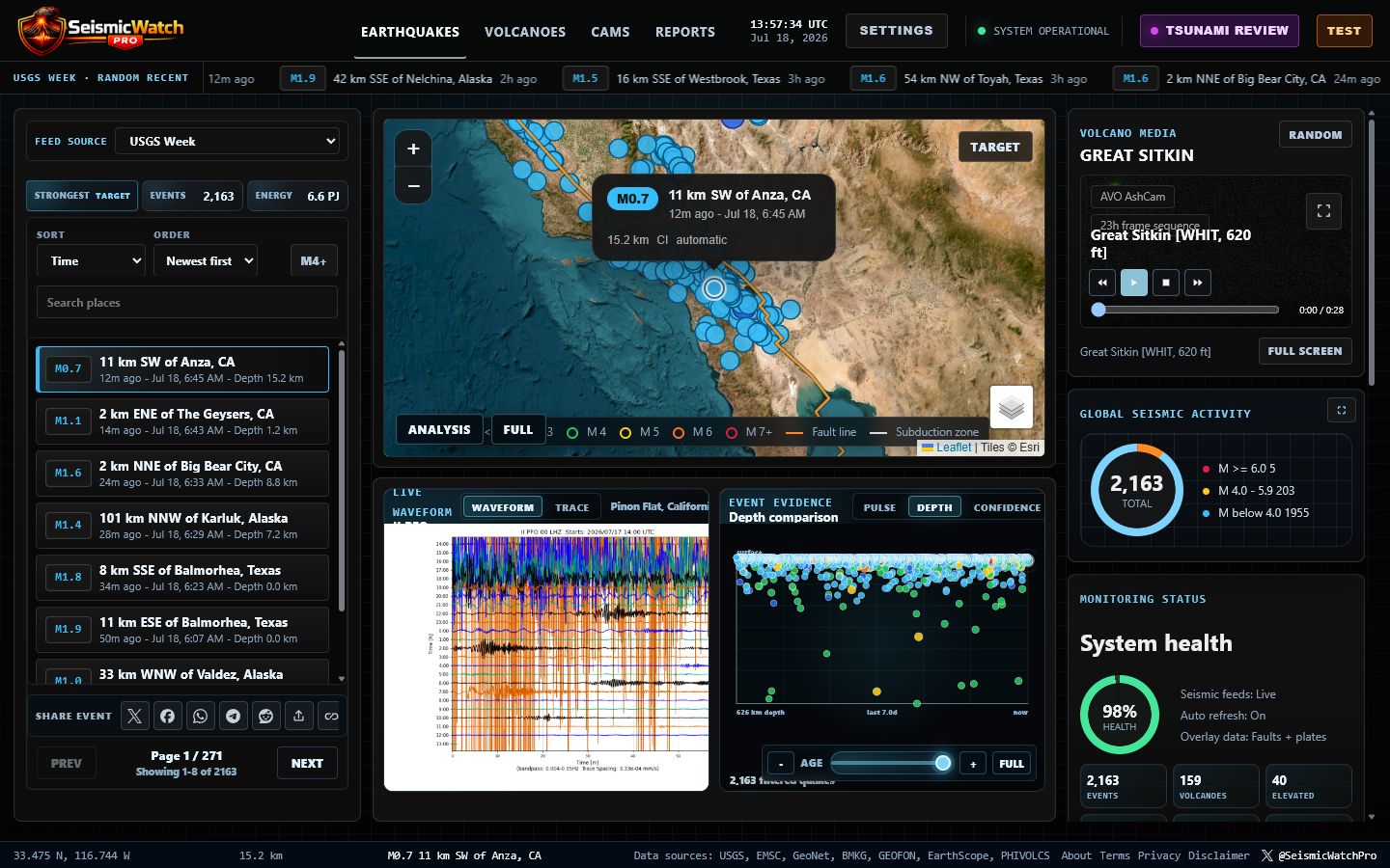
The new SeismicWatch.Pro web app is live.
SeismicWatch.Pro brings worldwide earthquake and volcano monitoring directly to the browser at SeismicWatch.Pro.
Open the site and the observatory is ready: a live earthquake map, connected event list, worldwide data feeds, volcano status, cams, analysis, scientific reports, an AI-assisted newsroom, configurable alerts, and a mobile layout designed for checking activity quickly.
Open the live SeismicWatch.Pro web app →
A Live Observatory In The Browser
The web app is designed as a focused monitoring console. The main dashboard connects the map, selected event, event list, ticker, waveform context, depth comparison, activity graphics, and monitoring status in one continuous workspace.
Users can move from a worldwide view to a specific earthquake without losing their place. Selecting an event updates the map, list, analysis, trace context, and share controls together. Map styles and user settings remain persistent between visits, while automatic updates continue in the background without pulling the user away from the section they are viewing.
Worldwide Earthquake Feeds
SeismicWatch.Pro combines live and near-live earthquake coverage from multiple providers, including:
- USGS hour, day, week, and month feeds
- EMSC / Seismic Portal
- GeoNet New Zealand
- BMKG Indonesia
- GEOFON GFZ
- PHIVOLCS
The default USGS Week view gives visitors useful context immediately. Feed controls support searching, magnitude filters, significant-event filtering, and sorting by time, magnitude, or depth. The ticker can use a feed independently from the main dashboard and can be customized by source, order, magnitude behavior, and speed.
An Interactive Map Connected To The Data
The map is the center of the experience. Earthquake markers use the same magnitude color system as event rows, cards, ticker badges, analysis graphics, and social previews. Faults, plate boundaries, subduction zones, volcanoes, and tsunami buoy information add geographic context without turning the map into an unreadable wall of labels.
Users can choose whether plate-boundary labels appear on hover or remain visible in a decluttered mode. Fullscreen mapping, target controls, persistent basemap selection, selected-event popups, and direct event links make the map useful for both quick checks and longer exploration.
Analysis, Waveforms, Traces, And Event Context
Magnitude and location are only the beginning. The Analysis view connects a selected earthquake to measurements and comparisons that help explain where it fits inside the active feed window.
Depending on available source products, the app can show event-centered traces, live station waveforms, magnitude and depth distributions, event rate, energy estimates, felt reports, confidence and cluster context, nearby activity, status, source network, and other scientific fields. Graphics scale for desktop and mobile, and expanded views are available when a closer look is useful.
Volcano Monitoring And Observatory Cams
Volcanoes have their own full monitoring workflow. SeismicWatch.Pro collects multi-observatory status information, elevated activity, alert levels, aviation color codes, recent notices, field updates, eruption context, coordinates, and available media.
The Cams section brings together supported observatory images, animations, videos, and frame sequences. Media players include practical playback controls, fullscreen viewing, and pagination on mobile so a phone does not try to load every camera at once.
Scientific Reports Without Waiting On The Model
The Reports section publishes cached scientific editions for multiple earthquake feeds, time windows, and volcano monitoring data. Each edition brings together measured statistics, non-redundant analysis, magnitude and depth graphics, notable-event tables, source fields, status notes, timestamps, limitations, and emergency-information disclaimers.
Reports can be downloaded as PDF, CSV, or JSON. The detailed writing is prepared asynchronously with a local model and validated against the source evidence. Cached editions mean visitors can open and download reports immediately instead of waiting for AI generation.
An Hourly, Source-Grounded Newsroom
The new News section scans worldwide earthquake, volcano, disaster, and observatory sources every hour. It watches international publishers, GDACS, INGV, the Osservatorio Vesuviano Campi Flegrei bulletin archive, and the app’s global monitoring feeds. A separate five-minute watcher looks for major earthquakes, tsunami flags, and significant eruption updates.
News articles are generated from a constrained evidence packet and validated before publication. If the local writing model is unavailable or produces unsupported wording, the newsroom saves a deterministic source-grounded fallback instead. Every article includes publication time, source attribution, safety language, a unique social image, sharing controls, and an optional Play Audio button. Article narration never starts automatically.
Alerts, Voice, Sharing, And Persistent Settings
Users can configure global alerts, magnitude thresholds, regional watchlists, alert sounds, volume, automatic map focus, overlays, ticker behavior, map style, and Web Voice selection. English is the automatic voice default, while other voices installed on the device remain available in Settings.
Earthquakes and newsroom articles can be shared through X, Facebook, WhatsApp, LinkedIn, Reddit, a device share menu, or a copied link. Event links open the exact earthquake on the map. News links open the selected article. Rich preview images are generated from the event or article data so shares carry useful context instead of a generic site image.
Built For Mobile Without Shrinking The Desktop App
The mobile browser experience is a purpose-built layout, not the desktop dashboard squeezed into a narrow screen. The map and event list are prioritized for fast monitoring, controls fit touch screens, event lists and cams use pagination, analysis panels fit the viewport, and News articles lead with their visual card, manual audio control, and an accessible vertical archive.
The desktop monitoring console remains dense and information-rich. Mobile removes the clutter that gets in the way when someone is checking the site from a phone.
Informational Monitoring, Not An Emergency Warning Service
SeismicWatch.Pro is an informational monitoring and exploration tool. Source data can be delayed, incomplete, duplicated, or revised. Automated analysis and newsroom writing do not predict earthquakes or eruptions and do not replace official alerts.
During an emergency, always follow local authorities, civil defense agencies, official observatories, and responsible earthquake, volcano, and tsunami warning centers.
Visit SeismicWatch.Pro
The web app is available now at https://seismicwatch.pro/.
Watch the map. Explore the feeds. Read the reports. Check the cams. Follow the newsroom. The planet is always doing something—and now the observatory is open in any modern browser.
—Cire